Engineering & independent research

Kush Rishi.

ML systems.
Evaluation.
Spatial intelligence.

I build software for ML evaluation and sensing systems, with an emphasis on measurement, uncertainty and reproducible engineering.

Currently GNSS Analyst at Xona · Montréal

Spatial correspondence01 / 03
REFERENCE / ESTIMATE / DISPLACEMENT
A geometric illustration. Research results appear below.
Three lines of inquiry01 · Model evaluation02 · Systems & sensing03 · Spatial uncertainty

Selected work

Software and research.

Working software, measured results and the failures that shaped the next question.

01 / ML evaluation & reliability

Model Regression
Forensics

What evidence can explain a model regression?

Compare saved classification predictions, check release requirements and inspect changed cases in a portable report. In the completed research study, simple baselines found both planted changes; model-based diagnostics added no consistent top-1 benefit.

FindingRepairing a failure does not always identify its cause.

Maintenance · Independent-user benefit unestablished

01 / Release investigationActual HTML report
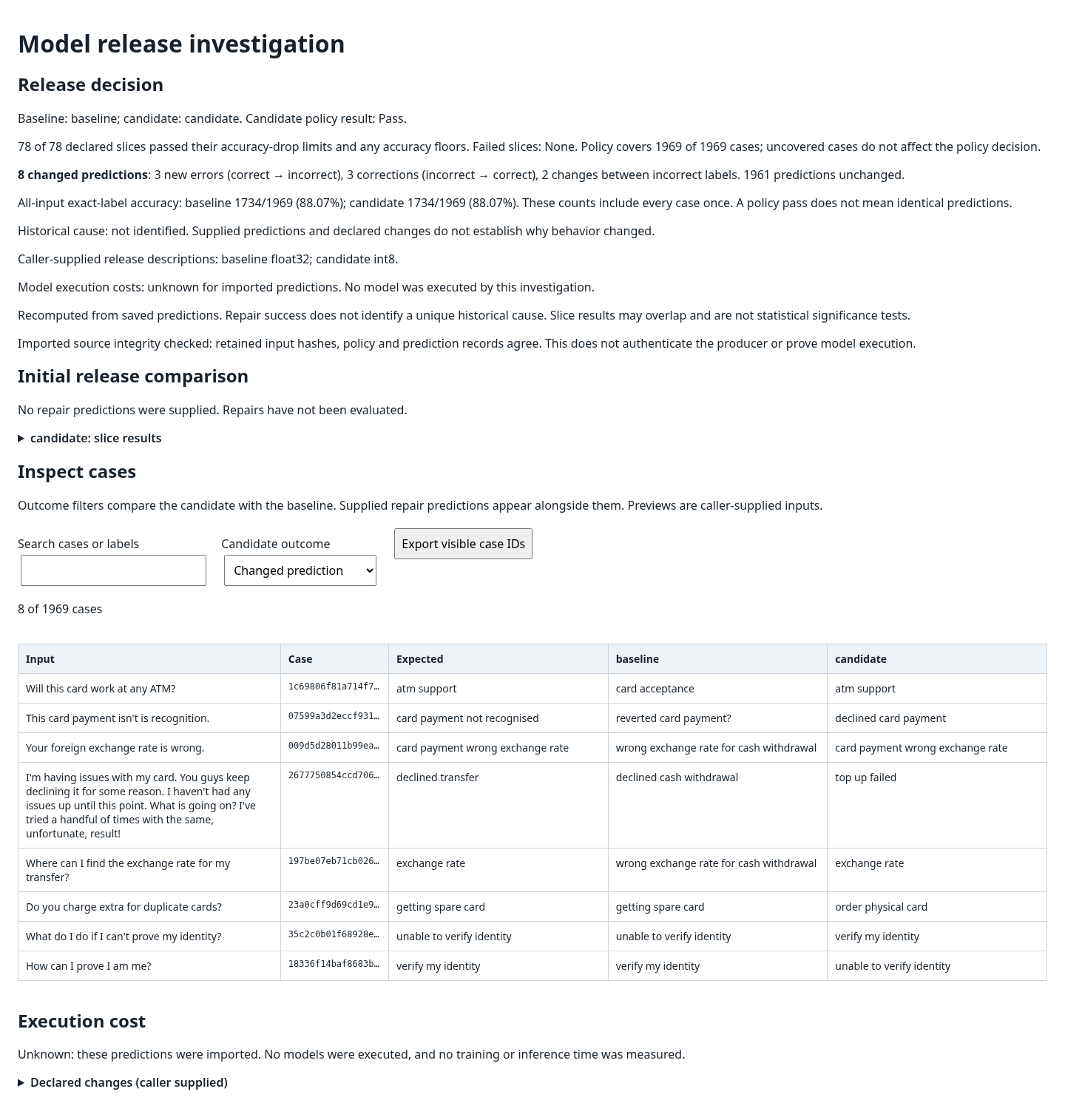
Passing release policy above a searchable table of eight changed Banking77 predictions, including three new errors and three corrections
1,969 cases; 78 passing slices; eight changed predictions. Three new errors, three corrections and two wrong-to-wrong changes leave aggregate accuracy unchanged. Owner-supplied capture; independent Chromium interaction check reported. Banking77: PolyAI, Casanueva et al. (2020), source, CC BY 4.0. Changes: case selection, predictions and grouping. Capture identity and limits.

02 / Systems & sensing

Autonomy
Simulation Lab

Make a sensing system’s assumptions inspectable.

A browser planning and localization simulator, alongside a native C++/Python tool that verifies recordings, runs CPU inference and compares processing configurations.

Verified8.9749% median whole-process reduction across three matched 108-frame native pairs; exact output parity.

Browser v1.0.2 · Maintenance · Owner Mac graphical review complete; independent first use pending

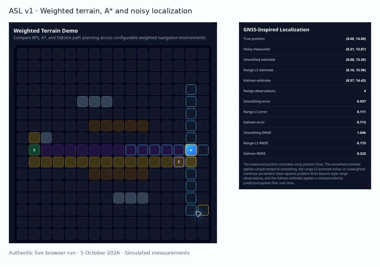
02 / Autonomy Simulation LabActual browser interface
Live ASL v1 weighted-terrain A-star route beside populated noisy-position, range least-squares and Kalman localization metrics
Captured from a completed weighted-terrain A* run on 5 October 2026. Simulated measurements; this is the browser v1, not native inference.

03 / Spatial uncertainty

TrueMargin

Can registration uncertainty reveal alignment error?

A controlled image-registration study finds useful rank information, alongside case-level reversals and high-error blind spots.

0.6841Median anatomy-level Spearman correlation
30 controlled cases · 10 anatomies
BoundaryUseful association. No established advantage over inverse-consistency error.

Controlled studies complete · External validation next

Controlled casesM4 / M5

Association can reverse

6 of 30cases had negative spread/error associations

Negative associationNonnegative

Ten source anatomies; three synthetic deformation cases per anatomy. No established advantage over inverse-consistency error. External validation pending. Inspect the recorded evidence.

What connects the work

How much should we
trust an output?

Evaluate the change.

Separate a suspicious training change from a verified repair and a uniquely supported cause.

Model evaluation

Locate the uncertainty.

Measure where a spatial estimate is informative, overconfident or too conservative to help.

Spatial intelligence

Inspect the system.

Make input identity, timing, failure handling and reproducibility part of the software contract.

Systems engineering

Experience

From measurements
to working systems.

Full experience & CV
2026–present

GNSS Analyst · Xona

Python and Linux workflows for positioning data, automated validation, monitoring and engineering analysis.

2025–2026

Research Assistant · UCalgary

LiDAR and photogrammetric point-cloud processing, spatial quality metrics and research visualizations.

2024

Survey Assistant · McElhanney

Control, layout and as-built measurements for the Valley Line West LRT extension.

Background

Measurement was
the starting point.

Geomatics taught me to ask what a measurement means, where its error comes from and whether the evidence supports the conclusion. That perspective carries into how I build software and study machine-learning systems.

At Xona, I work with real positioning data. Independently, I’m developing work in ML evaluation, spatial uncertainty and reproducible sensing systems. The questions differ; careful measurement matters in all of them.

Education

University of Calgary

BSc Geomatics Engineering
With Distinction · 2022–2026